


$2,900 / Month
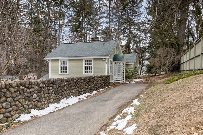
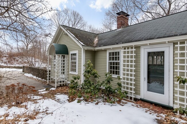
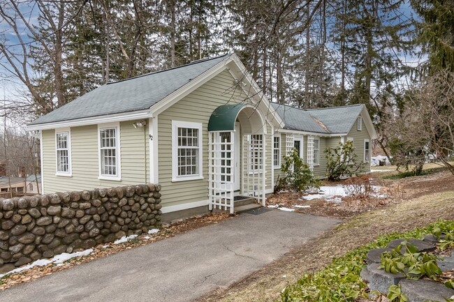
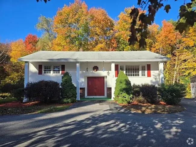
92 Farmers Row
Groton, MA 01450
Today
Favorites
508-864-7487
-
Bedrooms
2
-
Bathrooms
1
-
Square Feet
1,145 sq ft
-
Available
Available Now
Highlights
- Golf Course Community
- Community Stables
- Medical Services
- Custom Closet System
- Wood Flooring
- Upgraded Countertops
92 Farmers Row

Favorites
About This Home
$2,900 deposit,
Available Now
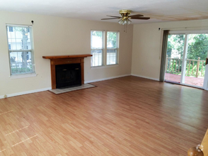
FOR-RENT in GROTON,MA – NOW AVAILABLE – MAGNIFICENT SUNSETS! Charming and Private 2 Bedroom,Detached Single Family Home,Near Groton Center! Walking Distance to all Town Center Shops and Eateries. Walking Distance to Lawrence Academy and Groton School. IDEAL Location! All Hardwood Floors,Beautifully Finished. FIREPLACE (limited use). Efficient Natural Gas Heating. Washer and Dryer Hookups. Dry Basement for Lots of Storage Space. FIOS TV and Internet Available. Pets are Negotiable.
92 Farmers Row is a house located in Middlesex County and the 01450 ZIP Code. This area is served by the Groton-Dunstable attendance zone.
* Price shown is base rent and may not include non-optional fees and utilities.
Price, availability, fees, and any applicable rent special are subject to change without notice.
* Square footage definitions vary. Displayed square footage is approximate.
Home Details
Home Type
Single Family Detached Home
Year Built
Built in 1930
Basement
Laundry in Basement
Exterior Basement Entry
Bedrooms and Bathrooms
Custom Closet System
Bathtub with Shower
1 Full Bathroom
2 Bedrooms
Flooring
Wood
Ceramic Tile
Interior Spaces
Living Room with Fireplace
1-Story Property
Ceiling Fan
Dining Area
Window Screens
Picture Window
1,145 Sq Ft Home
Kitchen
Upgraded Countertops
Stove
Range
Dishwasher
Listing and Financial Details
Security Deposit $2,900
Rent includes water, sewer, trash collection, garden area, occupancy only
Location
Property is near schools
Lot Details
Garden
Stone Wall
Near Conservation Area
Outdoor Features
Patio
Rain Gutters
Parking
4 Car Parking Spaces
Utilities
No Cooling
Heating System Uses Steam
High Speed Internet
Heating System Uses Natural Gas
Individual Controls for Heating
Cable TV Available
Community Details
Amenities
Medical Services
Shops
Overview
No Home Owners Association
Pet Policy
Call for details about the types of pets allowed
Recreation
Golf Course Community
Community Stables
Community Pool
Tennis Courts
Jogging Path
Park
Bike Trail
Contact
- Listed by Jeff Gordon | EXIT Assurance Realty
- Phone Number
-
Source
 MLS Property Information Network
The property listing data and information set forth herein were provided to MLS Property Information Network, Inc. from third party sources, including sellers, lessors and public records, and were compiled by MLS Property Information Network, Inc. The property listing data and information are for the personal, non-commercial use of consumers having a good faith interest in purchasing or leasing listed properties of the type displayed to them and may not be used for any purpose other than to identify prospective properties which such consumers may have a good faith interest in purchasing or leasing. MLS Property Information Network, Inc. and its subscribers disclaim any and all representations and warranties as to the accuracy of the property listing data and information set forth herein. All properties are subject to prior sale, change or withdrawal. Copyright © 2025 MLS Property Information Network, Inc. All rights reserved.
$2,879 / month
$435,000 Listing Price
3 Beds
•1 Baths
•
1,043 Sq Ft
$2,885 / month
$469,900 Listing Price
3 Beds
•1 Baths
•
960 Sq Ft
$2,934 / month
$470,000 Listing Price
3 Beds
•1.5 Baths
•
1,435 Sq Ft
Location
Get Directions
Amenities
- Dishwasher
- Range
- Refrigerator
- Patio
Education
| Colleges & Universities | Distance | ||
|---|---|---|---|
| Colleges & Universities | Distance | ||
| Drive: | 23 min | 11.6 mi | |
| Drive: | 30 min | 15.1 mi | |
| Drive: | 32 min | 16.3 mi | |
| Drive: | 32 min | 16.7 mi |
92 Farmers Row is within 23 minutes or 11.6 miles from Fitchburg State University. It is also near Rivier College and UMass Lowell.
Schools


Public Elementary School
Grades K-4
526 Students
Attendance Zone
Public Elementary & Middle School
Grades 5-8
723 Students
Attendance Zone
Public Elementary School
Grades PK-5
532 Students
Nearby
Public High School
Grades 9-12
680 Students
Attendance Zone
Private Elementary School
Grades PK-6
108 Students
Nearby
Private Middle & High School
Grades 8-12
371 Students
Nearby
Private Middle & High School
Grades 8-12
4 Students
Nearby
School data provided by
 The GreatSchools Rating helps parents compare schools within a state based on a variety of school quality indicators and provides a helpful picture of how effectively each school serves all of its students. Ratings are on a scale of 1 (below average) to 10 (above average) and can include test scores, college readiness, academic progress, advanced courses, equity, discipline and attendance data. We also advise parents to visit schools, consider other information on school performance and programs, and consider family needs as part of the school selection process.
View GreatSchools Rating Methodology
View GreatSchools Rating Methodology
Transportation options available in Groton include Alewife Station, located 31.6 miles from 92 Farmers Row. 92 Farmers Row is near Manchester Boston Regional, located 28.8 miles or 49 minutes away, and Worcester Regional, located 38.0 miles or 58 minutes away.
| Transit / Subway | Distance | ||
|---|---|---|---|
| Transit / Subway | Distance | ||
|
|
Drive: | 48 min | 31.6 mi |
|
|
Drive: | 51 min | 32.8 mi |
|
|
Drive: | 51 min | 33.1 mi |
|
|
Drive: | 52 min | 33.8 mi |
|
|
Drive: | 55 min | 35.4 mi |
| Commuter Rail | Distance | ||
|---|---|---|---|
| Commuter Rail | Distance | ||
|
|
Drive: | 7 min | 3.9 mi |
|
|
Drive: | 12 min | 6.6 mi |
|
|
Drive: | 18 min | 10.4 mi |
|
|
Drive: | 23 min | 11.9 mi |
|
|
Drive: | 27 min | 12.4 mi |
| Airports | Distance | ||
|---|---|---|---|
| Airports | Distance | ||
|
Manchester Boston Regional
|
Drive: | 49 min | 28.8 mi |
|
Worcester Regional
|
Drive: | 58 min | 38.0 mi |
Time and distance from 92 Farmers Row.
| Shopping Centers | Distance | ||
|---|---|---|---|
| Shopping Centers | Distance | ||
| Drive: | 3 min | 1.6 mi | |
| Drive: | 7 min | 4.3 mi | |
| Drive: | 9 min | 4.6 mi |
92 Farmers Row has 3 shopping centers within 4.6 miles, which is about a 9-minute drive. The miles and minutes will be for the farthest away property.
| Parks and Recreation | Distance | ||
|---|---|---|---|
| Parks and Recreation | Distance | ||
|
Nashua River Rail Trail
|
Drive: | 8 min | 3.4 mi |
|
MIT Haystack Observatory
|
Drive: | 14 min | 6.3 mi |
|
Mass Audubon's Nashoba Brook Wildlife Sanctuary
|
Drive: | 15 min | 8.3 mi |
|
Oxbow National Wildlife Refuge
|
Drive: | 18 min | 8.6 mi |
|
The Butterfly Place
|
Drive: | 19 min | 10.0 mi |
92 Farmers Row has 5 parks within 10.0 miles, including Nashua River Rail Trail, MIT Haystack Observatory, and Mass Audubon's Nashoba Brook Wildlife Sanctuary.
| Hospitals | Distance | ||
|---|---|---|---|
| Hospitals | Distance | ||
| Drive: | 7 min | 2.6 mi | |
| Drive: | 14 min | 7.4 mi |
92 Farmers Row is 2.6 miles from Nashoba Valley Medical Center, and is convenient to other hospitals, including TaraVista Behavioral Health Center.
You May Also Like
Similar Rentals Nearby


What Are Walk Score®, Transit Score®, and Bike Score® Ratings?
Walk Score® measures the walkability of any address. Transit Score® measures access to public transit. Bike Score® measures the bikeability of any address.
What is a Sound Score Rating?
A Sound Score Rating aggregates noise caused by vehicle traffic, airplane traffic and local sources

92 Farmers Row
Groton, MA 01450