
$2,999 / Month
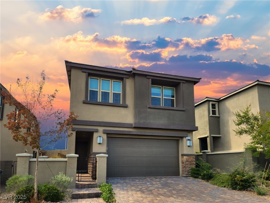
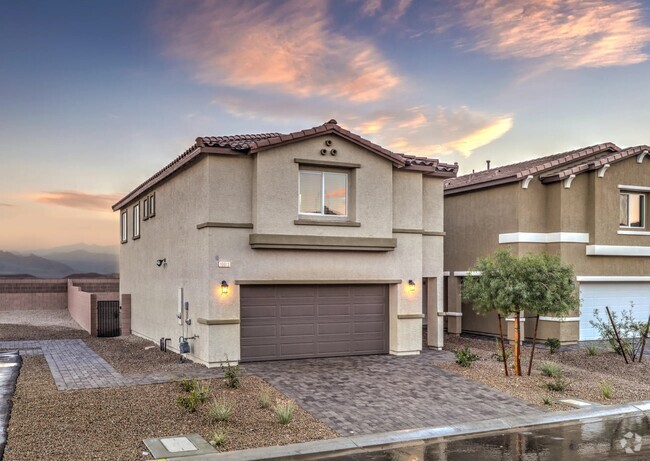
921 Ariel Heights Ave
Las Vegas, NV 89138
Today
Favorites
702-417-9003
-
Bedrooms
3
-
Bathrooms
3
-
Square Feet
1,592 sq ft
-
Available
Available Apr 1
Highlights
- 2 Car Attached Garage
- Park
- Security System Owned
- Community Barbecue Grill
- Porcelain Tile
- Central Heating and Cooling System
921 Ariel Heights Ave

Favorites
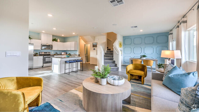
About This Home
Available Apr 1
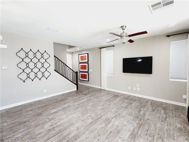
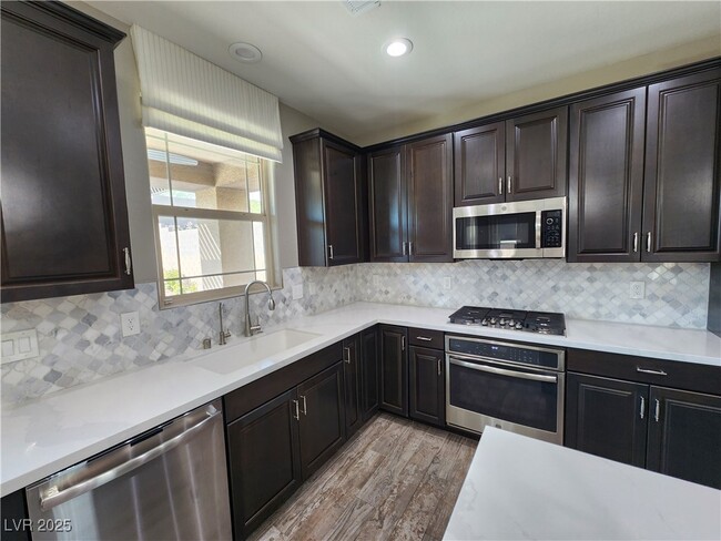
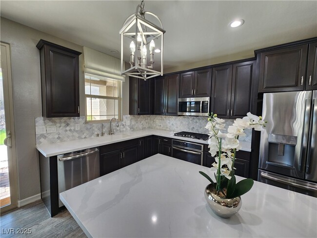
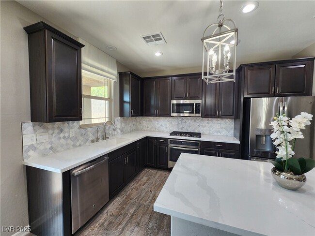
WOW - SAVE BIG ON ENERGY BILL WITH ALREADY INSTALLED SOLAR SYSTEM. Location Location Location, Too much to list... West SUMMERLIN Location, plenty of community parks & centers, Schools, Shopping, Dining, Entertainment , Near by RED ROCK CANYON & Blue Diamond PANORAMIC Nature & Vies... Was a Model Home, built in 2018, features 3 bedrooms, Custom flooring, wallpapers, SOLAR POWER System, Water Softener, Water Purifier, Surround Sound speakers in Living Room, LUSH & Cozy Backyard with Brand New BBQ Kitchenette, Recessed LED Lights in every room/area, Custom Shower in Primary Bedroom, Ceiling Fans in every room, Built In working desk on 2nd. floor, Epoxy finished Garage Floor & more... Alarm system current equipment is optional at $35/month. THIS WILL NOT LAST LONG !!!
921 Ariel Heights Ave is a house located in Clark County and the 89138 ZIP Code. This area is served by the Clark County attendance zone.
* Price shown is base rent and may not include non-optional fees and utilities.
Price, availability, fees, and any applicable rent special are subject to change without notice.
* Square footage definitions vary. Displayed square footage is approximate.
Home Details
Home Type
Single Family Detached Home
Year Built
Built in 2018
Bedrooms and Bathrooms
2.5 Bathrooms
3 Bedrooms
Flooring
Porcelain Tile
Carpet
Home Design
Tile Roof
Stucco
Frame Construction
Home Security
Security System Owned
Interior Spaces
Ceiling Fan
1,592 Sq Ft Home
2-Story Property
Blinds
Kitchen
Built-In Gas Oven
Gas Cooktop
Microwave
Dishwasher
Disposal
Laundry
Washer and Dryer
Laundry on upper level
Listing and Financial Details
Security Deposit $2,800
Property Available on 2/6/25
12 Month Lease Term
Tenant pays for cable TV, electricity, gas, key deposit, security, sewer, trash collection, water
Lot Details
4,356 Sq Ft Lot
North Facing Home
Back Yard Fenced
Block Wall Fence
Parking
2 Car Attached Garage
Schools
Vassiliadis Elementary School
Rogich Sig Middle School
Palo Verde High School
Utilities
Central Heating and Cooling System
Water Purifier
Water Softener is Owned
Heating System Uses Gas
Cable TV Not Available
Community Details
Amenities
Community Barbecue Grill
Overview
Property has a Home Owners Association
Summerlin West Association, Phone Number (702) 791-4600
Skye Knoll Phase 1 Subdivision
Pet Policy
No Pets Allowed
Recreation
Park
Contact
- Listed by Anat Meged | United Realty Group
- Phone Number
- Website View Property Website
- Contact
-
Source
 Greater Las Vegas Association of REALTORS®
©2025 Greater Las Vegas Association of REALTORS®. All rights reserved.
$3,299 / month
$550,000 Listing Price
4 Beds
•3 Baths
•
1,901 Sq Ft
$3,159 / month
$515,000 Listing Price
3 Beds
•3 Baths
•
1,583 Sq Ft
$3,411 / month
$575,000 Listing Price
4 Beds
•3 Baths
•
2,132 Sq Ft
Location
Get Directions
Amenities
- Washer/Dryer
- Air Conditioning
- Ceiling Fans
- Dishwasher
- Disposal
- Microwave
- Oven
- Range
- Refrigerator
- Carpet
- Tile Floors
Despite its “Sin City” reputation, Las Vegas has a huge personality that goes well beyond the glimmering neon of the Strip. In fact, many of the Strip’s most famous landmarks are actually outside of the Las Vegas city limits in Paradise, Nevada. The City of Las Vegas tends to be much more subdued overall, mainly comprised of residential neighborhoods and an exceptional selection of golf courses and country clubs. The community’s bike-friendly configuration has earned national recognition, and parents are able to choose between dozens of excellent public schools in the area. Outdoor exploration is always close at hand, with Lake Mead to the east and Red Rock Canyon to the west. The local arts and culture scene incorporates the glossy entertainment of the Strip, fine arts like ballet and classical music, and a hip local creative community.
Learn more about living in Las Vegas
Education
| Colleges & Universities | Distance | ||
|---|---|---|---|
| Colleges & Universities | Distance | ||
| Drive: | 17 min | 8.5 mi | |
| Drive: | 22 min | 12.0 mi | |
| Drive: | 29 min | 16.5 mi | |
| Drive: | 30 min | 18.9 mi |
921 Ariel Heights Ave is within 17 minutes or 8.5 miles from Southern Nevada, Charleston. It is also near Nev. State Coll., Shadow Lane and UNLV.
Schools

Public Elementary School
Grades PK-5
663 Students
Nearby
Public Middle School
Grades 6-8
1,587 Students
Attendance Zone
Public High School
Grades 9-12
3,186 Students
Attendance Zone
Private Elementary & Middle School
Grades PK-8
500 Students
Nearby
Private Elementary School
Grades K-5
51 Students
Nearby
Private Elementary School
Grades K-5
429 Students
Nearby
Private Middle & High School
Grades 6-12
1,937 Students
Nearby
School data provided by
 The GreatSchools Rating helps parents compare schools within a state based on a variety of school quality indicators and provides a helpful picture of how effectively each school serves all of its students. Ratings are on a scale of 1 (below average) to 10 (above average) and can include test scores, college readiness, academic progress, advanced courses, equity, discipline and attendance data. We also advise parents to visit schools, consider other information on school performance and programs, and consider family needs as part of the school selection process.
View GreatSchools Rating Methodology
View GreatSchools Rating Methodology
Transportation options available in Las Vegas include Sahara Station, located 13.5 miles from 921 Ariel Heights Ave. 921 Ariel Heights Ave is near Harry Reid International, located 19.8 miles or 27 minutes away, and Boulder City Municipal, located 39.4 miles or 52 minutes away.
| Transit / Subway | Distance | ||
|---|---|---|---|
| Transit / Subway | Distance | ||
|
|
Drive: | 24 min | 13.5 mi |
|
|
Drive: | 26 min | 14.1 mi |
|
|
Drive: | 27 min | 14.4 mi |
|
|
Drive: | 25 min | 14.9 mi |
|
|
Drive: | 26 min | 15.6 mi |
| Airports | Distance | ||
|---|---|---|---|
| Airports | Distance | ||
|
Harry Reid International
|
Drive: | 27 min | 19.8 mi |
|
Boulder City Municipal
|
Drive: | 52 min | 39.4 mi |
Time and distance from 921 Ariel Heights Ave.
| Shopping Centers | Distance | ||
|---|---|---|---|
| Shopping Centers | Distance | ||
| Drive: | 4 min | 1.7 mi | |
| Drive: | 7 min | 2.7 mi | |
| Drive: | 7 min | 3.0 mi |
921 Ariel Heights Ave has 3 shopping centers within 3.0 miles, which is about a 7-minute drive. The miles and minutes will be for the farthest away property.
| Parks and Recreation | Distance | ||
|---|---|---|---|
| Parks and Recreation | Distance | ||
|
Red Rock Canyon National Conservation Area
|
Drive: | 11 min | 5.4 mi |
|
Spring Mountain Ranch State Park
|
Drive: | 20 min | 10.9 mi |
|
Spring Mountains National Recreation Area
|
Drive: | 23 min | 12.9 mi |
921 Ariel Heights Ave has 3 parks within 12.9 miles, including Red Rock Canyon National Conservation Area, Spring Mountain Ranch State Park, and Spring Mountains National Recreation Area.
| Hospitals | Distance | ||
|---|---|---|---|
| Hospitals | Distance | ||
| Drive: | 10 min | 5.1 mi | |
| Drive: | 17 min | 9.6 mi | |
| Drive: | 15 min | 10.1 mi |
921 Ariel Heights Ave has 3 hospitals within 10.1 miles, the nearest is Summerlin Hospital Medical Center which is 5.1 miles away and a 10 minute drive.
| Military Bases | Distance | ||
|---|---|---|---|
| Military Bases | Distance | ||
| Drive: | 43 min | 26.8 mi |
921 Ariel Heights Ave is 26.8 miles and a 43 minute drive from Nellis Air Force Base.
You May Also Like
Similar Rentals Nearby


What Are Walk Score®, Transit Score®, and Bike Score® Ratings?
Walk Score® measures the walkability of any address. Transit Score® measures access to public transit. Bike Score® measures the bikeability of any address.
What is a Sound Score Rating?
A Sound Score Rating aggregates noise caused by vehicle traffic, airplane traffic and local sources

921 Ariel Heights Ave
Las Vegas, NV 89138