$5,895 / Month
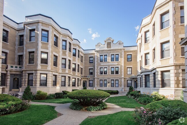
923 Beacon St Unit 2
Boston, MA 02215
Today
Favorites
781-551-3492
-
Bedrooms
4
-
Bathrooms
1.5
-
Square Feet
1,400 sq ft
-
Available
Available Now
Highlights
- Medical Services
- Property is near public transit
- Jogging Path
- No Cooling
- Park
- Shops
923 Beacon St Unit 2

Favorites
About This Home
$5,895 deposit,
Available Now
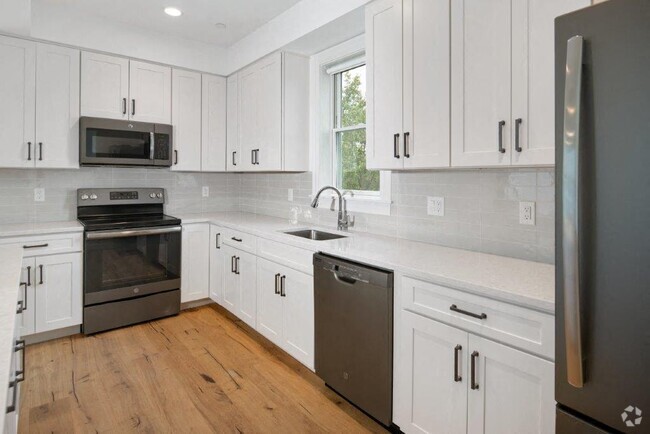
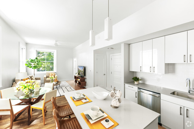
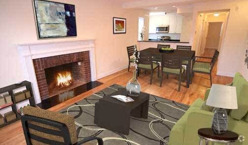
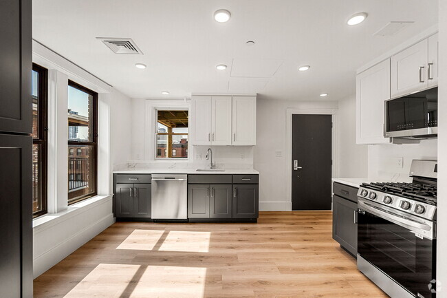
AVAILABLE NOW!! A spacious 4BD/1BA apartment,high ceilings,a decorative fireplace and lots of period details. This corner unit has lots of windows,both north-facing and west-facing. The combined living room/dining area is surrounded by natural woodwork plus a separate galley kitchen with generous cabinet & pantry storage. Located near Fenway / Kenmore Square overlooking Saint Mary's T-Stations (Green Line). Close proximity to Fenway Park and Longwood Medical Area with an abundance of neighborhood shops & restaurants around Fenway Triangle & Van Ness,plus a City-Target and Regal Cinemas. Grocery options include a newly arrived H-Market grocer store,Star Market,and a Whole Foods Market just a city block away. Flexible Lease terms.
923 Beacon St is an apartment community located in Suffolk County and the 02215 ZIP Code.
* Price shown is base rent and may not include non-optional fees and utilities.
Price, availability, fees, and any applicable rent special are subject to change without notice.
* Square footage definitions vary. Displayed square footage is approximate.
Home Details
Year Built
Built in 1935
Accessible Home Design
Entry on the 1st floor
Bedrooms and Bathrooms
1.5 Bathrooms
4 Bedrooms
Home Design
Apartment
Interior Spaces
1,400 Sq Ft Home
Kitchen
Range
Listing and Financial Details
Security Deposit $5,895
Property Available on 9/1/25
Assessor Parcel Number 3352276
Location
Property is near public transit
Property is near schools
Lot Details
3,114 Sq Ft Lot
Near Conservation Area
Utilities
No Cooling
Heating System Uses Natural Gas
Community Details
Amenities
Medical Services
Shops
Coin Laundry
Overview
No Home Owners Association
Pet Policy
Call for details about the types of pets allowed
Recreation
Jogging Path
Park
Fees and Policies
The fees below are based on community-supplied data and may exclude additional fees and utilities.
Pet policies are negotiable.
Contact
- Listed by Jagrti N. Patel | Premium Realty,Inc.
- Phone Number
-
Source
 MLS Property Information Network
The property listing data and information set forth herein were provided to MLS Property Information Network, Inc. from third party sources, including sellers, lessors and public records, and were compiled by MLS Property Information Network, Inc. The property listing data and information are for the personal, non-commercial use of consumers having a good faith interest in purchasing or leasing listed properties of the type displayed to them and may not be used for any purpose other than to identify prospective properties which such consumers may have a good faith interest in purchasing or leasing. MLS Property Information Network, Inc. and its subscribers disclaim any and all representations and warranties as to the accuracy of the property listing data and information set forth herein. All properties are subject to prior sale, change or withdrawal. Copyright © 2025 MLS Property Information Network, Inc. All rights reserved.
Location
Get Directions
Amenities
- Range
- Refrigerator
In a city so rich with history and culture, Fenway Park is arguably Boston’s most beloved attraction, and Audubon Circle is the perfect neighborhood for experiencing the electric energy surrounding “The Cathedral.” Although Fenway is only seven blocks from even the farthest point in Audubon Circle, it is far from the only noteworthy landmark within walking distance: amenities as diverse as Boston Beer Works, the Emerald Necklace park system, and a multiplex movie theater are all easily accessible on foot.
Most of the local apartments—which range from highly affordable to upscale-- are situated above ground-floor businesses in gorgeous historic brick buildings. Just across Saint Marys Street to the west, locals can reach a row of diverse restaurants, bakeries, and grocery stores. The Charles River and Boston University’s campus sit just a few blocks to the north; Amory Park and the New England Hebrew Academy are just minutes to the west.
Learn more about living in Audubon Circle
Education
| Colleges & Universities | Distance | ||
|---|---|---|---|
| Colleges & Universities | Distance | ||
| Walk: | 8 min | 0.4 mi | |
| Walk: | 9 min | 0.5 mi | |
| Walk: | 11 min | 0.6 mi | |
| Walk: | 11 min | 0.6 mi |
923 Beacon St Unit 2 is within 8 minutes or 0.4 mile from Lesley Univ., Art Institute. It is also near Boston University and Emmanuel College.
Transportation options available in Boston include St Mary's Street Station, located 0.1 mile from 923 Beacon St Unit 2. 923 Beacon St Unit 2 is near General Edward Lawrence Logan International, located 6.4 miles or 14 minutes away.
| Transit / Subway | Distance | ||
|---|---|---|---|
| Transit / Subway | Distance | ||
|
|
Walk: | 1 min | 0.1 mi |
|
|
Walk: | 4 min | 0.2 mi |
|
|
Walk: | 5 min | 0.3 mi |
|
|
Walk: | 7 min | 0.4 mi |
|
|
Walk: | 9 min | 0.5 mi |
| Commuter Rail | Distance | ||
|---|---|---|---|
| Commuter Rail | Distance | ||
|
|
Drive: | 3 min | 1.4 mi |
|
|
Drive: | 8 min | 2.1 mi |
| Drive: | 6 min | 2.9 mi | |
|
|
Drive: | 7 min | 3.8 mi |
| Drive: | 14 min | 6.7 mi |
| Airports | Distance | ||
|---|---|---|---|
| Airports | Distance | ||
|
General Edward Lawrence Logan International
|
Drive: | 14 min | 6.4 mi |
Time and distance from 923 Beacon St Unit 2.
| Shopping Centers | Distance | ||
|---|---|---|---|
| Shopping Centers | Distance | ||
| Walk: | 13 min | 0.7 mi | |
| Walk: | 14 min | 0.7 mi | |
| Drive: | 3 min | 1.3 mi |
923 Beacon St Unit 2 has 3 shopping centers within 1.3 miles, which is about a 3-minute walk. The miles and minutes will be for the farthest away property.
| Parks and Recreation | Distance | ||
|---|---|---|---|
| Parks and Recreation | Distance | ||
|
Coit Observatory
|
Walk: | 9 min | 0.5 mi |
|
John Fitzgerald Kennedy National Historic Site
|
Drive: | 3 min | 1.4 mi |
|
Charles River Reservation
|
Drive: | 3 min | 1.5 mi |
|
Roxbury Heritage State Park
|
Drive: | 4 min | 2.1 mi |
|
Frederick Law Olmsted National Historic Site
|
Drive: | 5 min | 2.4 mi |
923 Beacon St Unit 2 has 5 parks within 2.4 miles, including Coit Observatory, Charles River Reservation, and John Fitzgerald Kennedy National Historic Site.
| Hospitals | Distance | ||
|---|---|---|---|
| Hospitals | Distance | ||
| Walk: | 10 min | 0.6 mi | |
| Walk: | 16 min | 0.8 mi | |
| Walk: | 18 min | 1.0 mi |
923 Beacon St Unit 2 has 3 hospitals within 1.0 mile, the nearest is Beth Israel Deaconess Medical Center which is 0.6 mile away and a 10 minute walk.
| Military Bases | Distance | ||
|---|---|---|---|
| Military Bases | Distance | ||
| Drive: | 28 min | 14.4 mi | |
| Drive: | 26 min | 15.2 mi |
923 Beacon St Unit 2 is 14.4 miles from Hanscom Air Force Base, and is convenient to other military bases, including US Military Reservation.
You May Also Like
Similar Rentals Nearby
-
-
-
-
-
-
-
1 / 8
-
1 / 20
-
-


What Are Walk Score®, Transit Score®, and Bike Score® Ratings?
Walk Score® measures the walkability of any address. Transit Score® measures access to public transit. Bike Score® measures the bikeability of any address.
What is a Sound Score Rating?
A Sound Score Rating aggregates noise caused by vehicle traffic, airplane traffic and local sources
923 Beacon St
Boston, MA 02215