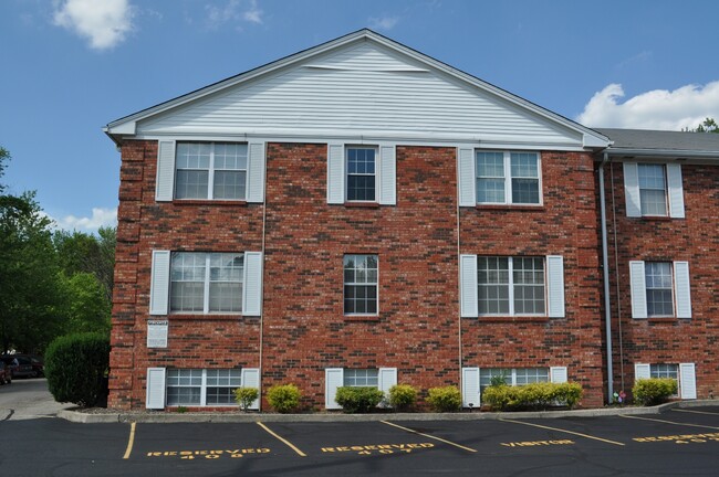
926 Ohio Pike Unit 412
Cincinnati, OH 45245

Check Back Soon for Upcoming Availability
| Beds | Baths | Average SF |
|---|---|---|
| 1 Bedroom 1 Bedroom 1 Br | 1 Bath 1 Bath 1 Ba | 650 SF |
About This Property
926 Ohio Pike is an apartment community located in Clermont County and the 45245 ZIP Code.
Apartment Features
Air Conditioning
Dishwasher
Refrigerator
Disposal
- Air Conditioning
- Smoke Free
- Dishwasher
- Disposal
- Kitchen
- Refrigerator
- Carpet
- Tile Floors
- Dining Room
- Laundry Facilities
Fees and Policies
The fees below are based on community-supplied data and may exclude additional fees and utilities.
- Parking
-
Surface Lot--
Details
Utilities Included
-
Water
-
Trash Removal
-
Sewer
Property Information
-
12 units
Withamsville exists as an unexpected springboard into the rest of suburban Cincinnati. The town is just 17 miles east of Cincinnati and just shy of 15 miles east of the Kentucky border. A small-town atmosphere encompassing wide, tree-lined streets and modest storefronts imbue Withamsville with a quiet charm. The Ohio Pike (State Route 125) is the area’s main artery and holds both national chain restaurants and locally owned cafes serving custard and down-home fare.
Withamsville rentals include affordable low-rise apartments and modern single-family home developments all near the conveniences of the town center. The neighborhood offers residents an easy commute into Downtown Cincinnati via Interstate 275 to the west, but there are a number of more suburban areas that open renters up to multiple employment opportunities as well. To the east you will find Elk Run Golf Course and the East Fork Wilderness area, meaning the beauty of the nearby countryside is just minutes away.
Learn more about living in WithamsvilleBelow are rent ranges for similar nearby apartments
- Air Conditioning
- Smoke Free
- Dishwasher
- Disposal
- Kitchen
- Refrigerator
- Carpet
- Tile Floors
- Dining Room
- Laundry Facilities
| Colleges & Universities | Distance | ||
|---|---|---|---|
| Colleges & Universities | Distance | ||
| Drive: | 14 min | 7.2 mi | |
| Drive: | 19 min | 12.9 mi | |
| Drive: | 27 min | 19.2 mi | |
| Drive: | 30 min | 20.8 mi |
Transportation options available in Cincinnati include Richter & Phillips Station, 6Th & Main, located 17.1 miles from 926 Ohio Pike Unit 412. 926 Ohio Pike Unit 412 is near Cincinnati/Northern Kentucky International, located 25.3 miles or 39 minutes away.
| Transit / Subway | Distance | ||
|---|---|---|---|
| Transit / Subway | Distance | ||
| Drive: | 22 min | 17.1 mi | |
| Drive: | 23 min | 17.2 mi | |
| Drive: | 23 min | 17.3 mi | |
| Drive: | 23 min | 17.4 mi | |
| Drive: | 23 min | 17.4 mi |
| Commuter Rail | Distance | ||
|---|---|---|---|
| Commuter Rail | Distance | ||
|
|
Drive: | 27 min | 19.3 mi |
| Airports | Distance | ||
|---|---|---|---|
| Airports | Distance | ||
|
Cincinnati/Northern Kentucky International
|
Drive: | 39 min | 25.3 mi |
Time and distance from 926 Ohio Pike Unit 412.
| Shopping Centers | Distance | ||
|---|---|---|---|
| Shopping Centers | Distance | ||
| Walk: | 11 min | 0.6 mi | |
| Drive: | 3 min | 1.3 mi | |
| Drive: | 3 min | 1.8 mi |
| Parks and Recreation | Distance | ||
|---|---|---|---|
| Parks and Recreation | Distance | ||
|
Woodland Mound Park
|
Drive: | 10 min | 5.0 mi |
|
Withrow Nature Preserve
|
Drive: | 10 min | 6.3 mi |
|
Cincinnati Nature Center - Rowe Woods
|
Drive: | 15 min | 6.9 mi |
|
Stanbery Park
|
Drive: | 15 min | 7.3 mi |
|
Little Miami State Park
|
Drive: | 22 min | 13.7 mi |
| Hospitals | Distance | ||
|---|---|---|---|
| Hospitals | Distance | ||
| Drive: | 11 min | 5.6 mi | |
| Drive: | 16 min | 10.0 mi |
| Military Bases | Distance | ||
|---|---|---|---|
| Military Bases | Distance | ||
| Drive: | 78 min | 62.6 mi | |
| Drive: | 84 min | 67.6 mi | |
| Drive: | 86 min | 70.9 mi |
You May Also Like
Similar Rentals Nearby
What Are Walk Score®, Transit Score®, and Bike Score® Ratings?
Walk Score® measures the walkability of any address. Transit Score® measures access to public transit. Bike Score® measures the bikeability of any address.
What is a Sound Score Rating?
A Sound Score Rating aggregates noise caused by vehicle traffic, airplane traffic and local sources


