


$7,500 / Month
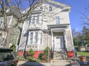
93 Power St
Providence, RI 02906
1 Day Ago
Favorites
617-513-9156
-
Bedrooms
5
-
Bathrooms
5
-
Square Feet
3,913 sq ft
-
Available
Available Jun 1
Highlights
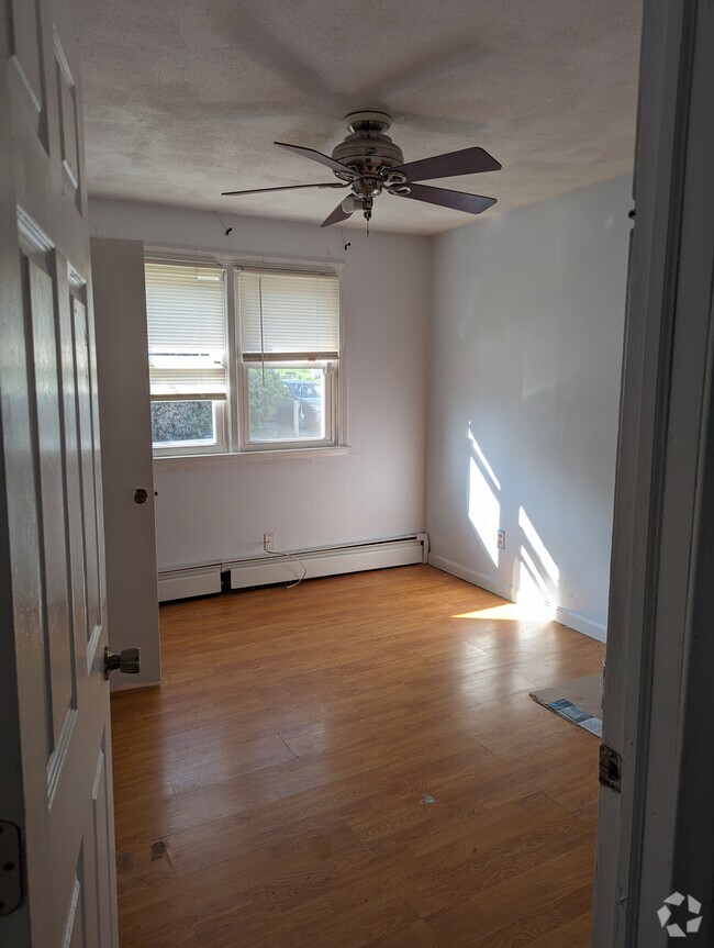
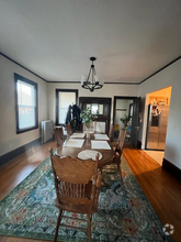
- Wood Flooring
- Victorian Architecture
- Furnished
- Tennis Courts
- Security System Owned
- Public Transportation
93 Power St

Favorites
About This Home
$7,500 deposit,
Available Jun 1
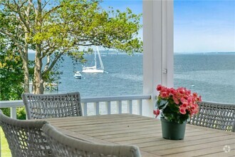
We are offering a fully furnished single family house rental located in the College Hill neighborhood for a short term Summer Rental with easy access to Brown,RISD,Downtown Providence and everything that the East Side has to offer. This remarkable Victorian home was completely remodeled last year and has old world charm coupled with todays designer finishes. There is a brand new chefs kitchen along with completely remodeled bathrooms throughout the house. The property also had brand new electrical and a new central AC system just installed. This home offers a laundry room,private patio area,off street parking and is available beginning on June 1 until August 31. The house is professionally managed and if there is ever any issue you will have someone to contact. To schedule a private showing give us a call.
93 Power St is a house located in Providence County and the 02906 ZIP Code. This area is served by the Providence attendance zone.
* Price shown is base rent and may not include non-optional fees and utilities.
Price, availability, fees, and any applicable rent special are subject to change without notice.
* Square footage definitions vary. Displayed square footage is approximate.
Home Details
Bedrooms and Bathrooms
4.5 Bathrooms
5 Bedrooms
Home Design
Victorian Architecture
Home Security
Security System Owned
Interior Spaces
Wood Flooring
Furnished
3,913 Sq Ft Home
3-Story Property
Kitchen
Range with Range Hood
Oven
Microwave
Dishwasher
Disposal
Laundry
Dryer
Laundry in unit
Washer
Listing and Financial Details
Property Available on 6/1/25
12 Month Lease Term
Assessor Parcel Number 93POWERSTPROV
Location
Property near a hospital
Parking
No Garage
2 Parking Spaces
Unfinished Basement
Basement Fills Entire Space Under The House
Utilities
Central Air
Baseboard Heating
Gas Water Heater
Heating System Uses Gas
Heat Pump System
Community Details
Amenities
Public Transportation
Shops
Restaurant
Overview
No Home Owners Association
College Hill/ East Side Subdivision
Pet Policy
No Pets Allowed
Recreation
Tennis Courts
Recreation Facilities
Fees and Policies
The fees below are based on community-supplied data and may exclude additional fees and utilities.
Details
Utilities Included
-
Water
Property Information
-
Furnished Units Available
Contact
- Listed by Gabe Francis | Lenox Realty Group
- Phone Number
- Contact
-
Source
State Wide MLS of Rhode Island, Inc.
Copyright © 2025 State Wide MLS of Rhode Island, Inc. All rights reserved. All information provided by the listing agent/broker is deemed reliable but is not guaranteed and should be independently verified.
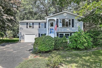
$3,353 / month
$529,900 Listing Price
6 Beds
•5 Baths
•
2,850 Sq Ft
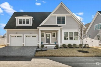
$5,457 / month
$851,000 Listing Price
5 Beds
•5 Baths
•
3,430 Sq Ft
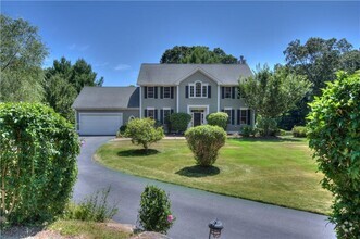
$5,450 / month
$875,000 Listing Price
6 Beds
•5.5 Baths
•
4,523 Sq Ft
Location
Get Directions
Amenities
- Air Conditioning
- Security System
- Fireplace
- Dishwasher
- Microwave
- Range
- Refrigerator
- Hardwood Floors
- Attic
- Views
- Furnished
- Pool
Expenses
Utilities Included
Water
Included
As its name implies, College Hill rises steeply from sea level to connect downtown to the city's East Side and is home to the prestigious Brown University and the Rhode Island School of Design. Boasting some of the city's best views, College Hill is adjacent to downtown, across the Providence River. This historic neighborhood and cultural hub is home to an eclectic mixture of architectural styles that few neighborhoods possess. Many of this cobbled-street neighborhood's historic homes date back to the Revolutionary era. The pre-Colonial towers of Brown University and post-modern structures of Rhode Island School of Design blend harmoniously with the juxtaposition of Federal, Greek Revival, and Neoclassical styles that characterize the area. Affordable student housing, sleek upscale apartments, and colorful single-family homes give a modern contrast to the neighborhood’s quaint feel.
Learn more about living in College Hill
Education
| Colleges & Universities | Distance | ||
|---|---|---|---|
| Colleges & Universities | Distance | ||
| Walk: | 8 min | 0.4 mi | |
| Walk: | 9 min | 0.5 mi | |
| Walk: | 16 min | 0.9 mi | |
| Walk: | 16 min | 0.9 mi |
93 Power St is within 8 minutes or 0.4 mile from Brown University. It is also near Rhode Island School of Design and C.C. of Rhode Island, Downcity.
Schools


Public Elementary School
Grades PK-5
407 Students
Attendance Zone
Public Elementary School
Grades K-5
251 Students
Attendance Zone
Public Middle School
Grades 6-8
631 Students
Attendance Zone
Public Middle School
Grades 6-8
608 Students
Attendance Zone
Public High School
Grades 9-12
1,113 Students
Attendance Zone
Public High School
Grades 9-12
896 Students
Attendance Zone
Private Elementary, Middle & High School
Grades PK-12
790 Students
Nearby
Private Elementary & Middle School
Grades PK-8
166 Students
Nearby
School data provided by
 The GreatSchools Rating helps parents compare schools within a state based on a variety of school quality indicators and provides a helpful picture of how effectively each school serves all of its students. Ratings are on a scale of 1 (below average) to 10 (above average) and can include test scores, college readiness, academic progress, advanced courses, equity, discipline and attendance data. We also advise parents to visit schools, consider other information on school performance and programs, and consider family needs as part of the school selection process.
View GreatSchools Rating Methodology
View GreatSchools Rating Methodology
Transportation options available in Providence include Mattapan Station, located 39.0 miles from 93 Power St. 93 Power St is near Rhode Island Tf Green International, located 8.5 miles or 18 minutes away.
| Transit / Subway | Distance | ||
|---|---|---|---|
| Transit / Subway | Distance | ||
|
|
Drive: | 54 min | 39.0 mi |
|
|
Drive: | 55 min | 39.4 mi |
|
|
Drive: | 55 min | 39.5 mi |
|
|
Drive: | 55 min | 40.3 mi |
|
|
Drive: | 57 min | 41.2 mi |
| Commuter Rail | Distance | ||
|---|---|---|---|
| Commuter Rail | Distance | ||
|
|
Walk: | 17 min | 0.9 mi |
| Drive: | 9 min | 4.8 mi | |
|
|
Drive: | 14 min | 7.8 mi |
| Drive: | 16 min | 8.6 mi | |
|
|
Drive: | 20 min | 12.6 mi |
| Airports | Distance | ||
|---|---|---|---|
| Airports | Distance | ||
|
Rhode Island Tf Green International
|
Drive: | 18 min | 8.5 mi |
Time and distance from 93 Power St.
| Shopping Centers | Distance | ||
|---|---|---|---|
| Shopping Centers | Distance | ||
| Walk: | 12 min | 0.6 mi | |
| Walk: | 17 min | 0.9 mi | |
| Walk: | 18 min | 1.0 mi |
93 Power St has 3 shopping centers within 1.0 mile, which is about a 18-minute walk. The miles and minutes will be for the farthest away property.
| Parks and Recreation | Distance | ||
|---|---|---|---|
| Parks and Recreation | Distance | ||
|
Roger Williams National Memorial
|
Walk: | 16 min | 0.8 mi |
|
Providence Children's Museum
|
Walk: | 16 min | 0.9 mi |
|
Ladd Observatory
|
Drive: | 3 min | 1.3 mi |
|
Roger Williams Park Zoo
|
Drive: | 9 min | 3.2 mi |
|
Woonasquatucket River Greenway - Riverside Park
|
Drive: | 7 min | 3.8 mi |
93 Power St has 5 parks within 3.8 miles, including Roger Williams National Memorial, Providence Children's Museum, and Ladd Observatory.
| Hospitals | Distance | ||
|---|---|---|---|
| Hospitals | Distance | ||
| Drive: | 3 min | 1.2 mi | |
| Drive: | 4 min | 1.5 mi | |
| Drive: | 7 min | 2.3 mi |
93 Power St has 3 hospitals within 2.3 miles, the nearest is Rhode Island Hospital which is 1.2 miles away and a 3 minute drive.
| Military Bases | Distance | ||
|---|---|---|---|
| Military Bases | Distance | ||
| Drive: | 34 min | 21.6 mi | |
| Drive: | 65 min | 42.3 mi |
93 Power St is 21.6 miles from Rhode Island National Gaurd, and is convenient to other military bases, including US Military Reservation.
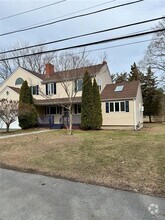
You May Also Like
Similar Rentals Nearby

What Are Walk Score®, Transit Score®, and Bike Score® Ratings?
Walk Score® measures the walkability of any address. Transit Score® measures access to public transit. Bike Score® measures the bikeability of any address.
What is a Sound Score Rating?
A Sound Score Rating aggregates noise caused by vehicle traffic, airplane traffic and local sources

93 Power St
Providence, RI 02906