-
Monthly Rent
$1,575
-
Bedrooms
1 bd
-
Bathrooms
1 ba
-
Square Feet
200 sq ft
Details

About This Property
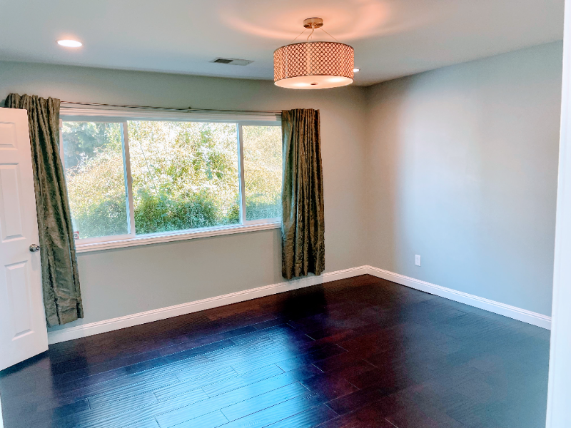
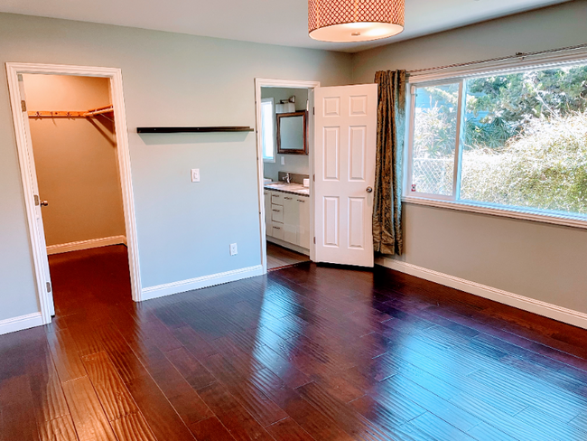
Property Id: 602369 Located in North Oakland and *very* close to the Berkeley and Emeryville borders! Your unfurnished or furnished 14' x 13' square foot primary bedroom with private bath and walk-in closet will be available soon in an 1850 sq ft single level 4 bedroom / 2 bath bungalow. This modern and contemporary bungalow has plenty of natural light, an open floor plan, and a fully stocked kitchen and furnished common area! * Rent includes Sonic High-Speed Internet, Gardener, and Housekeeper 2x/month (in the common areas & shared bathroom) * Nearby: 12 min walk to Ashby BART 4 min walk to SF Transbay F Bus 1 min walk to 88 Bus to UC Berkeley 8 min drive to Berkeley Bowl, Emeryville Mall, Ikea, Target, Rockridge, Temescal, Berkeley 93 bike score & 83 walk score PGE & Water: +$120/mo flat rate (with true up 2x/year) Can be available furnished: +$100/mo (see pic for details) More info here: .0
949 62nd St is a house located in Alameda County and the 94608 ZIP Code.
House Features
Washer/Dryer
Dishwasher
Microwave
Refrigerator
- Washer/Dryer
- Cable Ready
- Dishwasher
- Disposal
- Microwave
- Oven
- Refrigerator
- Freezer
- Tile Floors
- Furnished
- Fenced Lot
- Lawn
Fees and Policies
The fees below are based on community-supplied data and may exclude additional fees and utilities.
Details
Utilities Included
-
Trash Removal
-
Sewer
Property Information
-
Furnished Units Available
 This Property
 Available Property
- Washer/Dryer
- Cable Ready
- Dishwasher
- Disposal
- Microwave
- Oven
- Refrigerator
- Freezer
- Tile Floors
- Furnished
- Fenced Lot
- Lawn
Santa Fe is a small, residential neighborhood with a lot of heart. Colorful wall murals, churches, and sweet treats abound in Santa Fe. There are many options for satisfying your sweet tooth at local shops in Santa Fe including Marley’s Treats, It’s All Good Bakery, and Lois the Pie Queen. Santa Fe is also home to Temescal Creek Park and the Temescal Community Garden, for more opportunities to engage in outdoor activities.
Convenient to major highways in addition to multiple bus routes and BART stations, getting around from Santa Fe is easy. Travel plans are easily executed from Santa Fe too, with access to both Oakland International and San Francisco International Airports.
Learn more about living in Santa Fe| Colleges & Universities | Distance | ||
|---|---|---|---|
| Colleges & Universities | Distance | ||
| Drive: | 6 min | 2.2 mi | |
| Drive: | 6 min | 2.4 mi | |
| Drive: | 7 min | 3.3 mi | |
| Drive: | 10 min | 3.6 mi |
Transportation options available in Oakland include Ashby Station, located 0.7 mile from 949 62nd St. 949 62nd St is near Metro Oakland International, located 12.9 miles or 20 minutes away, and San Francisco International, located 22.4 miles or 35 minutes away.
| Transit / Subway | Distance | ||
|---|---|---|---|
| Transit / Subway | Distance | ||
|
|
Walk: | 14 min | 0.7 mi |
|
|
Drive: | 6 min | 2.1 mi |
|
|
Drive: | 6 min | 2.4 mi |
|
|
Drive: | 7 min | 3.0 mi |
|
|
Drive: | 7 min | 3.3 mi |
| Commuter Rail | Distance | ||
|---|---|---|---|
| Commuter Rail | Distance | ||
|
|
Drive: | 3 min | 1.1 mi |
|
|
Drive: | 7 min | 2.6 mi |
|
|
Drive: | 9 min | 4.1 mi |
| Drive: | 16 min | 10.0 mi | |
| Drive: | 18 min | 11.2 mi |
| Airports | Distance | ||
|---|---|---|---|
| Airports | Distance | ||
|
Metro Oakland International
|
Drive: | 20 min | 12.9 mi |
|
San Francisco International
|
Drive: | 35 min | 22.4 mi |
Time and distance from 949 62nd St.
| Shopping Centers | Distance | ||
|---|---|---|---|
| Shopping Centers | Distance | ||
| Drive: | 2 min | 1.1 mi | |
| Drive: | 2 min | 1.3 mi | |
| Drive: | 4 min | 1.4 mi |
| Parks and Recreation | Distance | ||
|---|---|---|---|
| Parks and Recreation | Distance | ||
|
Strawberry Creek Park
|
Drive: | 5 min | 1.8 mi |
|
Willard Park
|
Drive: | 6 min | 1.9 mi |
|
San Francisco Bay Trail (at Emeryville)
|
Drive: | 4 min | 2.0 mi |
|
Habitot Children's Museum
|
Drive: | 6 min | 2.2 mi |
|
People's Park
|
Drive: | 7 min | 2.3 mi |
| Hospitals | Distance | ||
|---|---|---|---|
| Hospitals | Distance | ||
| Walk: | 19 min | 1.0 mi | |
| Drive: | 5 min | 1.6 mi | |
| Drive: | 5 min | 2.3 mi |
| Military Bases | Distance | ||
|---|---|---|---|
| Military Bases | Distance | ||
| Drive: | 14 min | 5.5 mi | |
| Drive: | 16 min | 6.8 mi |
You May Also Like
What Are Walk Score®, Transit Score®, and Bike Score® Ratings?
Walk Score® measures the walkability of any address. Transit Score® measures access to public transit. Bike Score® measures the bikeability of any address.
What is a Sound Score Rating?
A Sound Score Rating aggregates noise caused by vehicle traffic, airplane traffic and local sources


