
960 DeKalb Ave
Brooklyn, NY 11221
-
Bedrooms
Studio
-
Bathrooms
1
-
Square Feet
--
-
Available
Available Apr 25
Highlight
- Controlled Access

About This Home
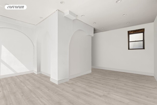
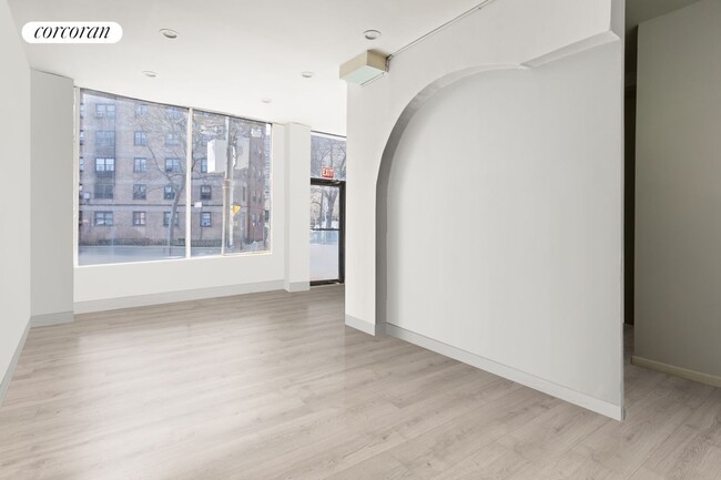
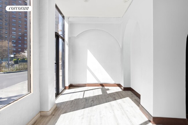
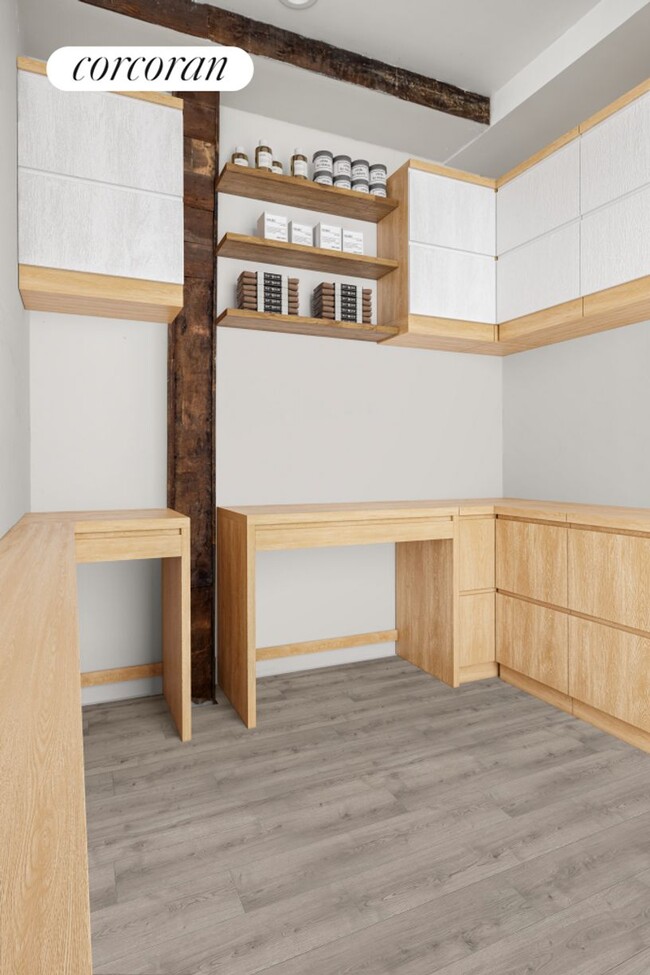
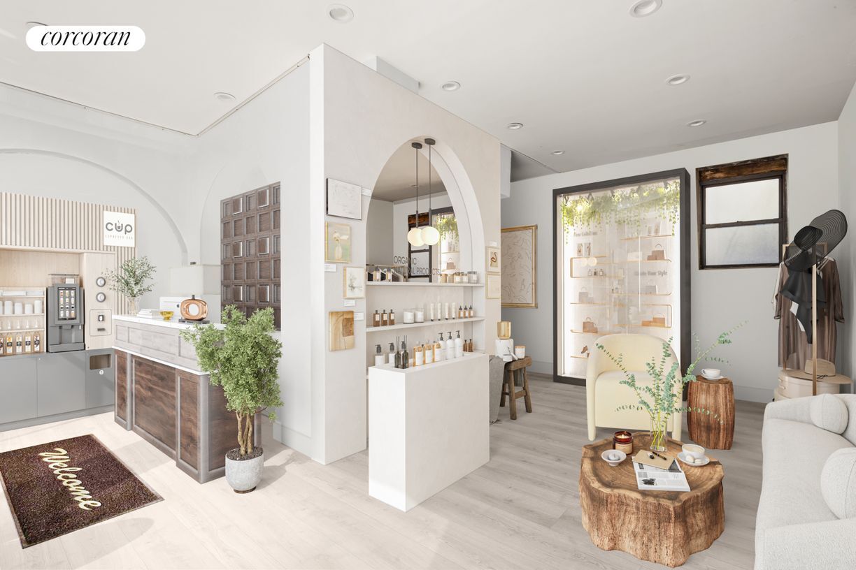
Set on one of Stuyvesant Heights most active corridors, this 633 square foot commercial space offers an ideal setting for retail or office use. With soaring 10'7" ceilings, the interior feels open and expansive, offering flexibility for a variety of layouts. A large built-in storage nook adds valuable functionality, making the space efficient and practical for day-to-day operations.Located along bustling Dekalb Avenue between Throop and Marcus Garvey, the property enjoys consistent through traffic and excellent visibility. The B38 and B43 bus lines run nearby, and the G, J, and M subway lines are easily accessible, providing strong connectivity throughout Brooklyn and into Manhattan. Whether you're a growing brand or an established business looking to expand, this location places you at the center of a thriving, high-traffic neighborhood.
960 DeKalb Ave is an apartment community located in Kings County and the 11221 ZIP Code.
Features
- Air Conditioning
- Package Service
- Laundry Facilities
- Controlled Access
Fees and Policies
The fees below are based on community-supplied data and may exclude additional fees and utilities.
Details
Lease Options
-
12 Months
Contact
- Website View Property Website
- Contact
-
Source

- Air Conditioning
- Package Service
- Laundry Facilities
- Controlled Access
As one of Brooklyn’s most eclectic neighborhoods, Stuyvesant Heights is a quaint urban neighborhood that boasts diversity, an abundance of mass transit, and historic charm. Located in the heart of Brooklyn, New York, this neighborhood houses some of the borough’s most historic brownstones and grand apartment buildings.
Though historic and vintage in appearance, the neighborhood is always improving with the addition of new restaurants, shops, and apartments around town. If you’re interested in bustling residential streets in a central urban location, you’ve found it. A plethora of apartment rentals reside along the historic streets of Stuyvesant Heights.
This neighborhood is the perfect blend of the old and the new. Explore tasty restaurants such as Peaches, a well-known place for modern, Southern cuisine in a historic brownstone. Enjoy numerous playgrounds, sports fields, and athletic courts within small green spaces around the neighborhood.
Learn more about living in Stuyvesant Heights| Colleges & Universities | Distance | ||
|---|---|---|---|
| Colleges & Universities | Distance | ||
| Drive: | 5 min | 1.4 mi | |
| Drive: | 5 min | 1.8 mi | |
| Drive: | 7 min | 2.3 mi | |
| Drive: | 9 min | 2.9 mi |
Transportation options available in Brooklyn include Myrtle Avenue, located 0.4 mile from 960 DeKalb Ave. 960 DeKalb Ave is near Laguardia, located 8.5 miles or 18 minutes away, and John F Kennedy International, located 11.0 miles or 21 minutes away.
| Transit / Subway | Distance | ||
|---|---|---|---|
| Transit / Subway | Distance | ||
|
|
Walk: | 7 min | 0.4 mi |
|
|
Walk: | 8 min | 0.4 mi |
|
|
Walk: | 11 min | 0.6 mi |
|
|
Walk: | 14 min | 0.7 mi |
|
|
Walk: | 15 min | 0.8 mi |
| Commuter Rail | Distance | ||
|---|---|---|---|
| Commuter Rail | Distance | ||
|
|
Drive: | 6 min | 1.8 mi |
|
|
Drive: | 6 min | 2.6 mi |
|
|
Drive: | 8 min | 2.8 mi |
|
|
Drive: | 12 min | 4.2 mi |
|
|
Drive: | 13 min | 4.5 mi |
| Airports | Distance | ||
|---|---|---|---|
| Airports | Distance | ||
|
Laguardia
|
Drive: | 18 min | 8.5 mi |
|
John F Kennedy International
|
Drive: | 21 min | 11.0 mi |
Time and distance from 960 DeKalb Ave.
| Shopping Centers | Distance | ||
|---|---|---|---|
| Shopping Centers | Distance | ||
| Drive: | 5 min | 1.9 mi | |
| Drive: | 7 min | 2.3 mi | |
| Drive: | 8 min | 2.5 mi |
| Parks and Recreation | Distance | ||
|---|---|---|---|
| Parks and Recreation | Distance | ||
|
Hattie Carthan Garden
|
Walk: | 13 min | 0.7 mi |
|
Martinez Playground
|
Drive: | 4 min | 1.3 mi |
|
Sternberg Park
|
Drive: | 4 min | 1.4 mi |
|
Maria Hernandez Park
|
Drive: | 4 min | 1.4 mi |
|
St. John's Park
|
Drive: | 6 min | 1.7 mi |
| Hospitals | Distance | ||
|---|---|---|---|
| Hospitals | Distance | ||
| Walk: | 12 min | 0.6 mi | |
| Drive: | 5 min | 1.4 mi | |
| Drive: | 4 min | 1.5 mi |
| Military Bases | Distance | ||
|---|---|---|---|
| Military Bases | Distance | ||
| Drive: | 19 min | 7.0 mi | |
| Drive: | 22 min | 11.3 mi |
You May Also Like
What Are Walk Score®, Transit Score®, and Bike Score® Ratings?
Walk Score® measures the walkability of any address. Transit Score® measures access to public transit. Bike Score® measures the bikeability of any address.
What is a Sound Score Rating?
A Sound Score Rating aggregates noise caused by vehicle traffic, airplane traffic and local sources
960 DeKalb Ave
Brooklyn, NY 11221