
$3,000
/ Month
9702 Tam O Shanter Dr
Upper Marlboro, MD 20772
2 Weeks Ago
|
Edit
Favorites
9702 Tam O Shanter Dr

Favorites
Check Back Soon for Upcoming Availability
| Beds | Baths | Average SF |
|---|---|---|
| 4 Bedrooms 4 Bedrooms 4 Br | 3 Baths 3 Baths 3 Ba | — |
About This Property
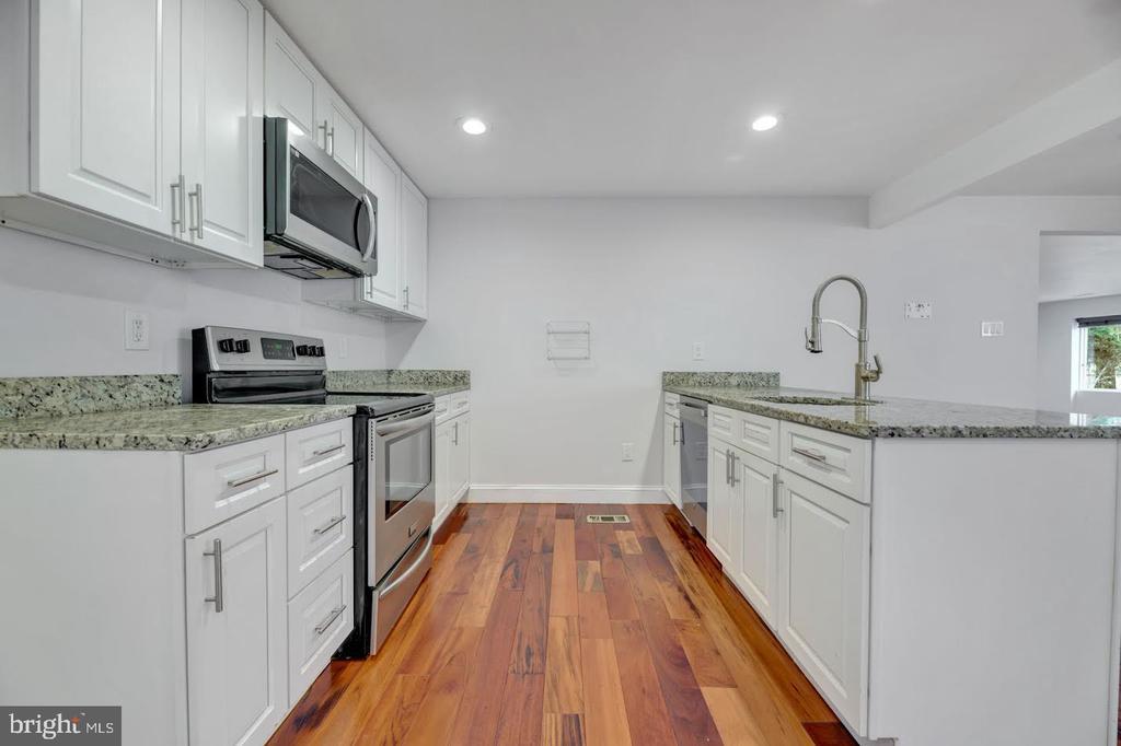
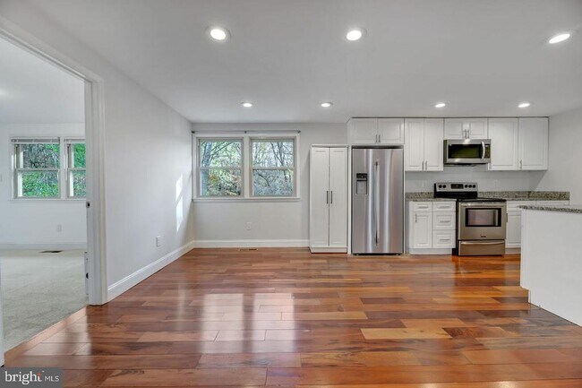
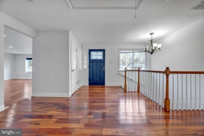
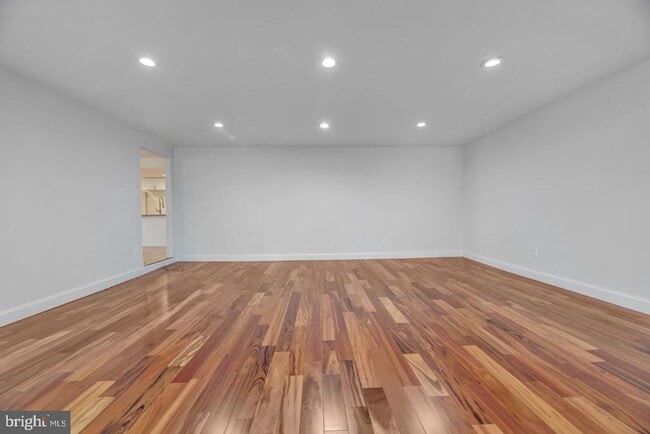
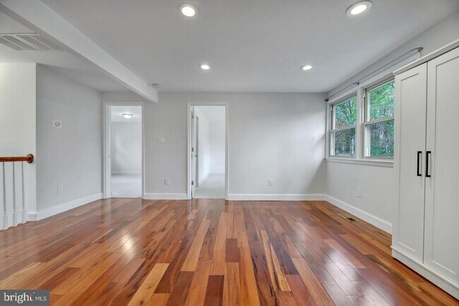
Come see this super cute single family home with large back yard. Open concept white soft close kitchen cabinets and stainless steel appliances. LVP flooring throughout and extra large living room! Finished basement with walk out level with screened in porch. 2 bedrooms and full bathrooms on main level and 2 bedrooms 1 bathroom in basement. Credit score is a 650, must make 3x the rent amount, pets case by case. NOTE Washer & dryer is as-is
9702 Tam O Shanter Dr is a house located in Prince George's County and the 20772 ZIP Code. This area is served by the Prince George's County Public Schools attendance zone.
House Features
- Basement
Location
Get Directions
The Marlton neighborhood is encompassed by modern conveniences like fast-casual dining and food marts. Residents enjoy the amenities at the Marlton Golf Club on Midland Turn, as well as the expansive green space at Charles Branch Stream Valley Park, which is in walking distance of their homes.
Another park just minutes down the road is Rosaryville State Park. At this park, visitors can walk, bike, or ride horses along the trails. The Mount Airy Mansion resides within the park – it dates back to the late 1600s and has been visited by seven U.S. presidents in its lifetime.
Marlton is right outside of Washington DC attractions, landmarks, and shopping destinations like the luxury shops and gourmet restaurants at CityCenterDC mall or Georgetown.
Learn more about living in MarltonBelow are rent ranges for similar nearby apartments
Amenities
- Basement
Education
| Colleges & Universities | Distance | ||
|---|---|---|---|
| Colleges & Universities | Distance | ||
| Drive: | 20 min | 12.4 mi | |
| Drive: | 24 min | 14.6 mi | |
| Drive: | 27 min | 15.4 mi | |
| Drive: | 35 min | 19.1 mi |
9702 Tam O Shanter Dr is within 20 minutes or 12.4 miles from Coll. of Southern Md., Waldorf. It is also near Prince George's Comm. Coll. and Univ. of Md. Univ. Coll..
Schools


Public Elementary School
Grades PK-5
454 Students
Nearby
Public Elementary School
Grades K-5
376 Students
Attendance Zone
Public Middle School
Grades 6-8
711 Students
Attendance Zone
Public High School
Grades 9-12
1,159 Students
Attendance Zone
Private Elementary & Middle School
Grades PK-8
231 Students
Nearby
School data provided by
 The GreatSchools Rating helps parents compare schools within a state based on a variety of school quality indicators and provides a helpful picture of how effectively each school serves all of its students. Ratings are on a scale of 1 (below average) to 10 (above average) and can include test scores, college readiness, academic progress, advanced courses, equity, discipline and attendance data. We also advise parents to visit schools, consider other information on school performance and programs, and consider family needs as part of the school selection process.
View GreatSchools Rating Methodology
Data provided by GreatSchools.org © 2025. All rights reserved.
View GreatSchools Rating Methodology
Data provided by GreatSchools.org © 2025. All rights reserved.
Transportation options available in Upper Marlboro include Branch Avenue, located 11.6 miles from 9702 Tam O Shanter Dr. 9702 Tam O Shanter Dr is near Ronald Reagan Washington Ntl, located 22.4 miles or 41 minutes away, and Baltimore/Washington International Thurgood Marshall, located 37.4 miles or 56 minutes away.
| Transit / Subway | Distance | ||
|---|---|---|---|
| Transit / Subway | Distance | ||
|
|
Drive: | 21 min | 11.6 mi |
|
|
Drive: | 26 min | 13.6 mi |
| Commuter Rail | Distance | ||
|---|---|---|---|
| Commuter Rail | Distance | ||
|
|
Drive: | 35 min | 18.2 mi |
| Drive: | 32 min | 19.1 mi | |
|
|
Drive: | 32 min | 19.1 mi |
|
|
Drive: | 33 min | 20.5 mi |
|
|
Drive: | 34 min | 20.5 mi |
| Airports | Distance | ||
|---|---|---|---|
| Airports | Distance | ||
|
Ronald Reagan Washington Ntl
|
Drive: | 41 min | 22.4 mi |
|
Baltimore/Washington International Thurgood Marshall
|
Drive: | 56 min | 37.4 mi |
Time and distance from 9702 Tam O Shanter Dr.
| Shopping Centers | Distance | ||
|---|---|---|---|
| Shopping Centers | Distance | ||
| Walk: | 10 min | 0.6 mi | |
| Drive: | 5 min | 2.5 mi | |
| Drive: | 13 min | 6.2 mi |
9702 Tam O Shanter Dr has 3 shopping centers within 6.2 miles, which is about a 13-minute drive. The miles and minutes will be for the farthest away property.
| Parks and Recreation | Distance | ||
|---|---|---|---|
| Parks and Recreation | Distance | ||
|
Rosaryville State Park
|
Drive: | 5 min | 2.0 mi |
|
Cheltenham Wetlands Park
|
Drive: | 11 min | 6.7 mi |
|
Patuxent Rural Life Museums
|
Drive: | 18 min | 7.5 mi |
|
Jug Bay Natural Area
|
Drive: | 18 min | 7.5 mi |
|
Mount Calvert Historical and Archaeological Park
|
Drive: | 19 min | 7.5 mi |
9702 Tam O Shanter Dr has 5 parks within 7.5 miles, including Rosaryville State Park, Cheltenham Wetlands Park, and Patuxent Rural Life Museums.
| Hospitals | Distance | ||
|---|---|---|---|
| Hospitals | Distance | ||
| Drive: | 13 min | 6.1 mi |
9702 Tam O Shanter Dr is 6.1 miles and a 13 minute drive from MedStar Southern Maryland Hospital Center.
| Military Bases | Distance | ||
|---|---|---|---|
| Military Bases | Distance | ||
| Drive: | 18 min | 8.3 mi |
9702 Tam O Shanter Dr is 8.3 miles and a 18 minute drive from Andrews Airforce Base.
You May Also Like
Similar Rentals Nearby


What Are Walk Score®, Transit Score®, and Bike Score® Ratings?
Walk Score® measures the walkability of any address. Transit Score® measures access to public transit. Bike Score® measures the bikeability of any address.
What is a Sound Score Rating?
A Sound Score Rating aggregates noise caused by vehicle traffic, airplane traffic and local sources

9702 Tam O Shanter Dr
Upper Marlboro, MD 20772