-
Pacific Heights
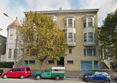
Pacific Heights
2135 California St,
San Francisco,
CA
94115
2 Weeks Ago
Favorites
Pacific Heights

Favorites
Check Back Soon for Upcoming Availability
| Beds | Baths | Average SF | Availability |
|---|---|---|---|
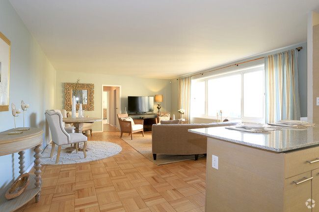
| 2 Bedrooms 2 Bedrooms 2 Br | 2 Baths 2 Baths 2 Ba | 1,367 SF | Not Available |
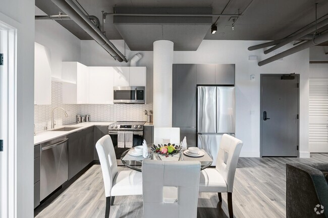
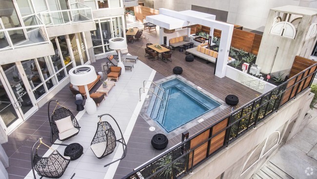
About Pacific Heights
Experience San Francisco living at Pacific Heights. You'll find this community at 2135 California St in the Lower Pacific Heights area of San Francisco. The leasing team is ready for you to come see our property. It's time to love where you live. Stop by for a visit today.
Pacific Heights is an apartment community located in San Francisco County and the 94115 ZIP Code. This area is served by the San Francisco Unified attendance zone.
Fees and Policies
Details
Property Information
-
Built in 1922
-
13 units/3 stories
Property Address:
2135 California St,
San Francisco,
CA
94115
Lower Pacific Heights is a vibrant San Francisco neighborhood situated between Pacific Heights, Japantown, the Fillmore District, and Laurel Heights. Formerly known as Upper Fillmore, Lower Pacific Heights offers residents a wide variety of apartments, condos, and houses available for rent, many of which boast scenic views due to the neighborhood’s hilly environment.
Lower Pacific Heights is regarded for its walkable layout, with many rentals situated within easy walking distance of the diverse restaurants, shops, coffeehouses, and bars that line Fillmore Street, the community’s main commercial thoroughfare. The neighborhood’s central locale is a major part of its allure, providing quick access to Union Square, the University of San Francisco, the Financial District, several prominent medical centers, tech employers, landmarks, and more.
Learn more about living in Lower Pacific HeightsBelow are rent ranges for similar nearby apartments
Education
| Colleges & Universities | Distance | ||
|---|---|---|---|
| Colleges & Universities | Distance | ||
| Walk: | 15 min | 0.8 mi | |
| Drive: | 4 min | 1.4 mi | |
| Drive: | 5 min | 1.9 mi | |
| Drive: | 6 min | 2.1 mi |
Pacific Heights is within 15 minutes or 0.8 mile from UC San Francisco, Mount Zion. It is also near Academy of Art University and University of San Francisco.
Schools
Public Elementary School
Grades K-5
118 Students
Nearby
6
Out of 10
Charter Elementary & Middle School
Grades 5-8
278 Students
Nearby
6
Out of 10
Public Elementary School
Grades K-5
287 Students
Attendance Zone
5
Out of 10
Public Elementary School
Grades K-5
347 Students
Nearby
2
Out of 10
Public Middle School
Grades 6-8
676 Students
Attendance Zone
5
Out of 10
Charter High School
Grades 9-12
489 Students
Attendance Zone
8
Out of 10
Private Elementary, Middle & High School
Grades K-12
404 Students
Nearby
Private Elementary & Middle School
Grades K-8
426 Students
Nearby
Private High School
Grades 9-12
203 Students
Nearby
School data provided by
GreatSchools
The GreatSchools Rating helps parents compare schools within a state based on a variety of school quality indicators and provides a helpful picture of how effectively each school serves all of its students. Ratings are on a scale of 1 (below average) to 10 (above average) and can include test scores, college readiness, academic progress, advanced courses, equity, discipline and attendance data. We also advise parents to visit schools, consider other information on school performance and programs, and consider family needs as part of the school selection process.
Transportation options available in San Francisco include Van Ness And California, located 0.4 mile from Pacific Heights. Pacific Heights is near San Francisco International, located 14.9 miles or 24 minutes away, and Metro Oakland International, located 20.5 miles or 33 minutes away.
| Transit / Subway | Distance | ||
|---|---|---|---|
| Transit / Subway | Distance | ||
|
|
Walk: | 8 min | 0.4 mi |
|
|
Walk: | 11 min | 0.6 mi |
|
|
Walk: | 13 min | 0.7 mi |
|
|
Walk: | 16 min | 0.8 mi |
|
|
Walk: | 17 min | 0.9 mi |
| Commuter Rail | Distance | ||
|---|---|---|---|
| Commuter Rail | Distance | ||
| Drive: | 7 min | 2.6 mi | |
| Drive: | 9 min | 4.1 mi | |
| Drive: | 13 min | 7.0 mi | |
|
|
Drive: | 18 min | 10.1 mi |
|
|
Drive: | 22 min | 12.1 mi |
| Airports | Distance | ||
|---|---|---|---|
| Airports | Distance | ||
|
San Francisco International
|
Drive: | 24 min | 14.9 mi |
|
Metro Oakland International
|
Drive: | 33 min | 20.5 mi |
Time and distance from Pacific Heights.
| Shopping Centers | Distance | ||
|---|---|---|---|
| Shopping Centers | Distance | ||
| Walk: | 7 min | 0.4 mi | |
| Walk: | 10 min | 0.6 mi | |
| Walk: | 15 min | 0.8 mi |
Pacific Heights has 3 shopping centers within 0.8 mile, which is about a 15-minute walk. The miles and minutes will be for the farthest away property.
| Parks and Recreation | Distance | ||
|---|---|---|---|
| Parks and Recreation | Distance | ||
|
San Francisco Maritime National Historical Park
|
Drive: | 5 min | 1.9 mi |
|
Children's Creativity Museum
|
Drive: | 6 min | 2.0 mi |
|
Exploratorium
|
Drive: | 5 min | 2.1 mi |
|
Buena Vista Park
|
Drive: | 6 min | 2.2 mi |
|
Aquarium of The Bay
|
Drive: | 7 min | 2.4 mi |
Pacific Heights has 5 parks within 2.4 miles, including San Francisco Maritime National Historical Park, Exploratorium, and Children's Creativity Museum.
| Hospitals | Distance | ||
|---|---|---|---|
| Hospitals | Distance | ||
| Walk: | 13 min | 0.7 mi | |
| Walk: | 15 min | 0.8 mi | |
| Drive: | 4 min | 1.4 mi |
Pacific Heights has 3 hospitals within 1.4 miles, the nearest is California Pacific Medical Center - Van Ness Campus which is 0.7 mile away and a 13 minutes drive.
| Military Bases | Distance | ||
|---|---|---|---|
| Military Bases | Distance | ||
| Drive: | 12 min | 4.2 mi | |
| Drive: | 13 min | 4.6 mi | |
| Drive: | 15 min | 6.6 mi |
Pacific Heights has 3 military bases within 6.6 miles, the nearest is East Fort Miley which is 4.2 miles away and a 12 minutes .
You May Also Like
What neighborhood is the property located in?
Pacific Heights is in Lower Pacific Heights in the city of San Francisco. Here you’ll find three shopping centers within 0.8 mile of the property. Five parks are within 2.4 miles, including San Francisco Maritime National Historical Park, Exploratorium, and Children's Creativity Museum.
Similar Rentals Nearby


What Are Walk Score®, Transit Score®, and Bike Score® Ratings?
Walk Score® measures the walkability of any address. Transit Score® measures access to public transit. Bike Score® measures the bikeability of any address.
What is a Sound Score Rating?
A Sound Score Rating aggregates noise caused by vehicle traffic, airplane traffic and local sources

2135 California St
San Francisco, CA 94115
Responded To This Review