
Serramonte Ridge
862 Campus Dr,
Daly City, CA 94015
$2,149 - $3,140
Studio - 2 Beds

Bedrooms
1 - 2 bd
Bathrooms
1 - 2 ba
Square Feet
756 sq ft
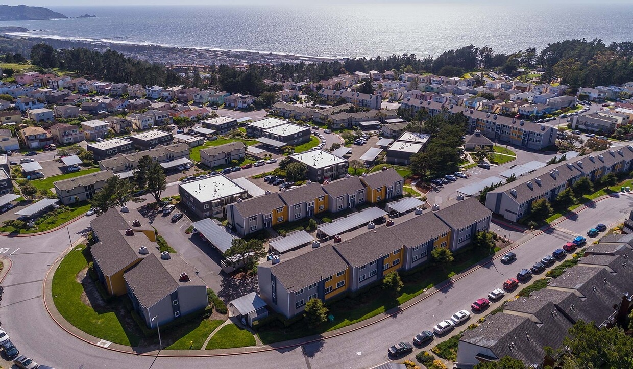
Pacifica Park Apartments in Pacifica, CA 94044 is a smoke free community. Homes have fully equipped kitchens, spacious living rooms, large closets and extra storage space. Some apartments feature new windows, ceiling fans, linen closets and carports or garages. Smart home technology available in every home! Pet friendly community with dog park, on site recycling, complimentary coffee and 24 hour laundry centers in each building. Located less than a mile from the Pacific Coast Highway, 10 minutes from the BART station and 15 minutes from San Francisco Airport and Bay Bridge. Guarantors welcome! We offer many virtual options including live video tours, 3D virtual tours, and text.
Pacifica Park Apartments in Pacifica, CA 94044 is a smoke free community. Homes have fully equipped kitchens, spacious living rooms, large closets and extra storage space. Some apartments feature new windows, ceiling fans, linen closets and carports or garages. Smart home technology available in every home! Pet friendly community with dog park, on site recycling, complimentary coffee and 24 hour laundry centers in each building. Located less than a mile from the Pacific Coast Highway, 10 minutes from the BART station and 15 minutes from San Francisco Airport and Bay Bridge. Guarantors welcome! We offer many virtual options including live video tours, 3D virtual tours, and text.
Pacifica Park is an apartment community located in San Mateo County and the 94044 ZIP Code. This area is served by the Pacifica attendance zone.
Unique Features
Balancing close proximity to San Francisco, miles of stunning Pacific coastline, and wooded hills all around, Pacifica residents enjoy one of the most desirable locations in the Bay Area. The rugged landscape of San Pedro Valley Park and Sweeney Ridge envelop and overlap much of the upscale suburban community, making it an ideal city for folks who love hiking and mountain biking.
The local arts community is quite active, with live music, theater performances, and gallery shows happening constantly. To top it all off, San Francisco is less than thirty minutes up Interstate 280, making it easy to get into The City for work or just to take advantage of the urban landscape as change of scenery.
Learn more about living in Pacifica| Colleges & Universities | Distance | ||
|---|---|---|---|
| Colleges & Universities | Distance | ||
| Drive: | 7 min | 3.3 mi | |
| Drive: | 10 min | 5.8 mi | |
| Drive: | 10 min | 6.2 mi | |
| Drive: | 16 min | 8.4 mi |


Transportation options available in Pacifica include South San Francisco Station, located 2.7 miles from Pacifica Park. Pacifica Park is near San Francisco International, located 8.1 miles or 14 minutes away, and Metro Oakland International, located 30.8 miles or 43 minutes away.
| Transit / Subway | Distance | ||
|---|---|---|---|
| Transit / Subway | Distance | ||
|
|
Drive: | 6 min | 2.7 mi |
|
|
Drive: | 6 min | 2.7 mi |
|
|
Drive: | 5 min | 2.9 mi |
|
|
Drive: | 7 min | 4.2 mi |
|
|
Drive: | 9 min | 5.5 mi |
| Commuter Rail | Distance | ||
|---|---|---|---|
| Commuter Rail | Distance | ||
| Drive: | 11 min | 5.4 mi | |
| Drive: | 9 min | 5.6 mi | |
| Drive: | 14 min | 9.0 mi | |
| Drive: | 15 min | 10.1 mi | |
| Drive: | 14 min | 10.2 mi |
| Airports | Distance | ||
|---|---|---|---|
| Airports | Distance | ||
|
San Francisco International
|
Drive: | 14 min | 8.1 mi |
|
Metro Oakland International
|
Drive: | 43 min | 30.8 mi |
Time and distance from Pacifica Park.
| Shopping Centers | Distance | ||
|---|---|---|---|
| Shopping Centers | Distance | ||
| Walk: | 3 min | 0.2 mi | |
| Walk: | 18 min | 0.9 mi | |
| Walk: | 20 min | 1.1 mi |
| Parks and Recreation | Distance | ||
|---|---|---|---|
| Parks and Recreation | Distance | ||
|
Pacifica State Beach
|
Drive: | 8 min | 5.3 mi |
|
San Francisco Zoo
|
Drive: | 10 min | 5.9 mi |
|
San Francisco State Univ. Observatory
|
Drive: | 11 min | 6.5 mi |
|
Charles F. Hagar Planetarium
|
Drive: | 11 min | 6.5 mi |
|
San Bruno Mountain State Park
|
Drive: | 15 min | 6.8 mi |
| Hospitals | Distance | ||
|---|---|---|---|
| Hospitals | Distance | ||
| Drive: | 4 min | 1.7 mi | |
| Drive: | 6 min | 2.8 mi | |
| Drive: | 11 min | 7.9 mi |
| Military Bases | Distance | ||
|---|---|---|---|
| Military Bases | Distance | ||
| Drive: | 20 min | 10.2 mi | |
| Drive: | 23 min | 10.4 mi |
What Are Walk Score®, Transit Score®, and Bike Score® Ratings?
Walk Score® measures the walkability of any address. Transit Score® measures access to public transit. Bike Score® measures the bikeability of any address.
What is a Sound Score Rating?
A Sound Score Rating aggregates noise caused by vehicle traffic, airplane traffic and local sources
670 Hickey Blvd
Pacifica, CA 94044


