$2,350 / Month
472 Sackett St Unit 02
Brooklyn, NY 11231
2 Weeks Ago
Favorites
SACKETT STREET

Favorites
Check Back Soon for Upcoming Availability
| Beds | Baths | Average SF |
|---|---|---|
| 2 Bedrooms 2 Bedrooms 2 Br | 1 Bath 1 Bath 1 Ba | — |
About This Property
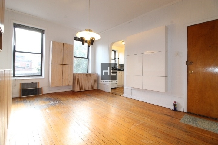
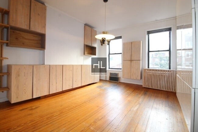
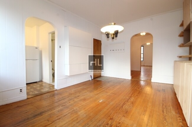
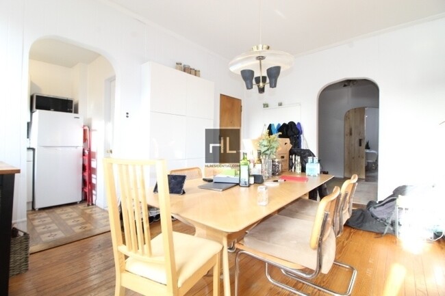
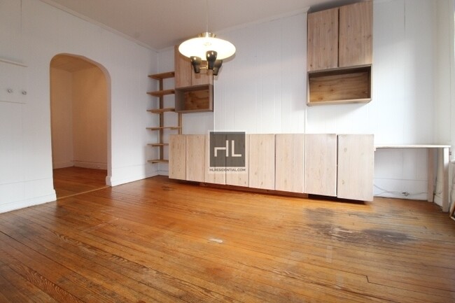
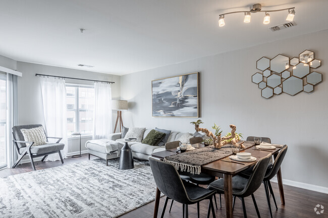
BEAUTIFUL LAYOUT - NO FEE1.5 Blocks from Smith st. Includes the Following: Hardwood FloorsGenerous Closet SpaceKing size BedroomOffice room could fit full size bed. ( Preview before and after pictures with furniture )Cat Friendly2nd Floor walk-up Make an appointment Today!!===Ref:854105===
SACKETT STREET is an apartment community located in Kings County and the 11231 ZIP Code.
Location
Get Directions
Neighboring Boerum Hill and Cobble Hill in Brooklyn, Carroll Gardens is equal parts historic and hip. Classic brownstones and modern high-rise apartments comprise the bulk of the rental options in Carroll Gardens. While the neighborhood is distinctly urban, Carroll Gardens embraces the outdoors with lush tree-lined streets and numerous community parks.
Carroll Gardens is home to a close-knit community, which supports a thriving small business scene. Residents enjoy access to a host of popular restaurants, unique boutiques, cozy cafes, artisanal food shops, local pizzerias, hip bars, and great public schools in the neighborhood. Getting around from Carroll Gardens is easy with its walkable design and quick access to I-278, I-478, and multiple subway stations.
Learn more about living in Carroll GardensBelow are rent ranges for similar nearby apartments
Education
| Colleges & Universities | Distance | ||
|---|---|---|---|
| Colleges & Universities | Distance | ||
| Walk: | 17 min | 0.9 mi | |
| Walk: | 19 min | 1.0 mi | |
| Drive: | 4 min | 1.3 mi | |
| Drive: | 5 min | 1.4 mi |
SACKETT STREET is within 17 minutes or 0.9 mile from ASA College Brooklyn. It is also near Long Island Univ., Brooklyn and Brooklyn Law School.
Transportation options available in Brooklyn include Carroll Street, located 0.4 mile from SACKETT STREET. SACKETT STREET is near Laguardia, located 10.7 miles or 21 minutes away, and Newark Liberty International, located 15.4 miles or 27 minutes away.
| Transit / Subway | Distance | ||
|---|---|---|---|
| Transit / Subway | Distance | ||
|
|
Walk: | 7 min | 0.4 mi |
|
|
Walk: | 9 min | 0.5 mi |
|
|
Walk: | 10 min | 0.6 mi |
|
|
Walk: | 13 min | 0.7 mi |
|
|
Drive: | 4 min | 1.2 mi |
| Commuter Rail | Distance | ||
|---|---|---|---|
| Commuter Rail | Distance | ||
|
|
Drive: | 6 min | 1.6 mi |
|
|
Drive: | 9 min | 3.2 mi |
|
|
Drive: | 13 min | 4.4 mi |
|
|
Drive: | 13 min | 4.5 mi |
|
|
Drive: | 19 min | 7.1 mi |
| Airports | Distance | ||
|---|---|---|---|
| Airports | Distance | ||
|
Laguardia
|
Drive: | 21 min | 10.7 mi |
|
Newark Liberty International
|
Drive: | 27 min | 15.4 mi |
Time and distance from SACKETT STREET.
| Shopping Centers | Distance | ||
|---|---|---|---|
| Shopping Centers | Distance | ||
| Drive: | 4 min | 1.2 mi | |
| Drive: | 5 min | 1.7 mi | |
| Drive: | 5 min | 1.9 mi |
SACKETT STREET has 3 shopping centers within 1.9 miles, which is about a 5-minute drive. The miles and minutes will be for the farthest away property.
| Parks and Recreation | Distance | ||
|---|---|---|---|
| Parks and Recreation | Distance | ||
|
Gowanus Canal
|
Walk: | 6 min | 0.3 mi |
|
Cobble Hill Park
|
Walk: | 15 min | 0.8 mi |
|
Red Hook Park
|
Drive: | 4 min | 1.5 mi |
|
Coffey Park
|
Drive: | 5 min | 1.5 mi |
|
Fort Greene Park
|
Drive: | 6 min | 1.7 mi |
SACKETT STREET has 5 parks within 1.7 miles, including Gowanus Canal, Cobble Hill Park, and Fort Greene Park.
| Hospitals | Distance | ||
|---|---|---|---|
| Hospitals | Distance | ||
| Drive: | 6 min | 1.7 mi | |
| Drive: | 6 min | 2.0 mi | |
| Drive: | 11 min | 3.9 mi |
SACKETT STREET has 3 hospitals within 3.9 miles, the nearest is Brooklyn Hospital Center - Downtown Campus which is 1.7 miles away and a 6 minute drive.
| Military Bases | Distance | ||
|---|---|---|---|
| Military Bases | Distance | ||
| Drive: | 11 min | 4.6 mi | |
| Drive: | 26 min | 12.8 mi |
SACKETT STREET is 4.6 miles from Governors Island Support Center, and is convenient to other military bases, including Military Ocean Terminal.
You May Also Like
Similar Rentals Nearby


What Are Walk Score®, Transit Score®, and Bike Score® Ratings?
Walk Score® measures the walkability of any address. Transit Score® measures access to public transit. Bike Score® measures the bikeability of any address.
What is a Sound Score Rating?
A Sound Score Rating aggregates noise caused by vehicle traffic, airplane traffic and local sources

472 Sackett St
Brooklyn, NY 11231