
The Preserve at Owings Crossing Apartment Homes
10 Brookebury Dr,
Reisterstown, MD 21136
$1,270 - $2,860
Studio - 3 Beds
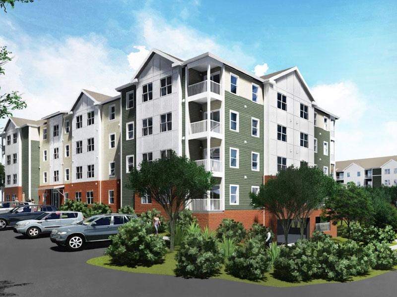
The Preserve at Red Run is a brand new energy efficient apartment community located in Owings Mills, MD, surrounded by a Forest Conservation area - providing a quiet and relaxing atmosphere. These spacious one, two and three bedroom apartment homes were designed for families in Northwestern Baltimore County, offering the best of location and amenities - shopping, dining, entertainment, I-795, and so much more are just minutes from your front door. The Preserve at Red Run is equipped with a beautiful community room, perfect for entertaining, as well as a fitness center and computer lab. Come join our community today!
The Preserve at Red Run is an apartment community located in Baltimore County and the 21117 ZIP Code. This area is served by the Baltimore County Public Schools attendance zone.
Unique Features
Fitness Center
Laundry Facilities
Elevator
Playground
Air Conditioning
Dishwasher
Washer/Dryer Hookup
Refrigerator
Located in Baltimore County, Owings Mills combines suburban living with easy city access. This community northwest of Baltimore features natural attractions like Soldiers Delight Natural Environment Area, known for its rare serpentinite ecosystem. Residents enjoy convenient transportation via the Baltimore Metro Subway and shopping at Mill Station and Foundry Row, home to Wegmans and Costco. One-bedroom apartments in Owings Mills rent for $1,579 monthly, while two-bedroom units average $1,897, reflecting a 2.5% year-over-year increase.
The area is home to McDonogh School and Stevenson University, while major employers include T. Rowe Price, CareFirst, and the Baltimore Ravens' headquarters. Maryland Public Television studios adds to the community's media presence. With approximately 35,700 residents, Owings Mills offers various housing options from apartment communities to established neighborhoods, all within easy reach of Baltimore's attractions.
Learn more about living in Owings Mills| Colleges & Universities | Distance | ||
|---|---|---|---|
| Colleges & Universities | Distance | ||
| Drive: | 8 min | 3.0 mi | |
| Drive: | 16 min | 6.7 mi | |
| Drive: | 27 min | 11.0 mi | |
| Drive: | 25 min | 13.5 mi |


Transportation options available in Owings Mills include Old Court, located 4.9 miles from The Preserve at Red Run. The Preserve at Red Run is near Baltimore/Washington International Thurgood Marshall, located 18.7 miles or 33 minutes away.
| Transit / Subway | Distance | ||
|---|---|---|---|
| Transit / Subway | Distance | ||
| Drive: | 10 min | 4.9 mi | |
| Drive: | 16 min | 6.4 mi | |
| Drive: | 19 min | 8.1 mi | |
| Drive: | 15 min | 8.3 mi | |
| Drive: | 20 min | 8.9 mi |
| Commuter Rail | Distance | ||
|---|---|---|---|
| Commuter Rail | Distance | ||
| Drive: | 25 min | 14.1 mi | |
|
|
Drive: | 25 min | 14.2 mi |
|
|
Drive: | 28 min | 14.4 mi |
|
|
Drive: | 29 min | 16.9 mi |
|
|
Drive: | 32 min | 18.4 mi |
| Airports | Distance | ||
|---|---|---|---|
| Airports | Distance | ||
|
Baltimore/Washington International Thurgood Marshall
|
Drive: | 33 min | 18.7 mi |
Time and distance from The Preserve at Red Run.
| Shopping Centers | Distance | ||
|---|---|---|---|
| Shopping Centers | Distance | ||
| Walk: | 10 min | 0.5 mi | |
| Walk: | 17 min | 0.9 mi | |
| Walk: | 17 min | 0.9 mi |
| Parks and Recreation | Distance | ||
|---|---|---|---|
| Parks and Recreation | Distance | ||
|
Irvine Nature Center
|
Drive: | 8 min | 3.5 mi |
|
Soldiers Delight Natural Environment Area (NEA)
|
Drive: | 9 min | 3.9 mi |
|
Rodgers Farms
|
Drive: | 13 min | 6.0 mi |
|
Patapsco Valley State Park
|
Drive: | 23 min | 8.8 mi |
|
Mt Pleasant - Howard County Conservancy
|
Drive: | 22 min | 10.1 mi |
| Hospitals | Distance | ||
|---|---|---|---|
| Hospitals | Distance | ||
| Drive: | 7 min | 3.4 mi | |
| Drive: | 19 min | 8.4 mi | |
| Drive: | 22 min | 9.4 mi |
| Military Bases | Distance | ||
|---|---|---|---|
| Military Bases | Distance | ||
| Drive: | 47 min | 26.7 mi |
What Are Walk Score®, Transit Score®, and Bike Score® Ratings?
Walk Score® measures the walkability of any address. Transit Score® measures access to public transit. Bike Score® measures the bikeability of any address.
What is a Sound Score Rating?
A Sound Score Rating aggregates noise caused by vehicle traffic, airplane traffic and local sources

9000 Garth Rd
Owings Mills, MD 21117


